How to Find Hidden Gem Hiking Trails Right in Your Backyard
Imagine discovering a pristine waterfall just 20 minutes from your home, or stumbling upon a scenic ridge trail that rivals those found in national parks—all without traveling hundreds of miles or fighting tourist crowds. The truth is, hidden gem hiking trails exist everywhere, even in areas you might consider ordinary or overdeveloped. These lesser-known paths offer the same sense of adventure and natural beauty as famous destinations, but with the added benefits of convenience, solitude, and the thrill of genuine discovery.
Disclosure: This post contains affiliate links. As an Amazon Associate, we earn from qualifying purchases, and at no extra cost to you.

Whether you live in a bustling city, quiet suburb, or rural area, your backyard likely contains hiking treasures waiting to be explored. The key lies in knowing where to look and how to research these hidden trails effectively.
Key Takeaways
- Local knowledge beats online popularity – The best hidden trails are often known only to locals and aren’t heavily promoted online
- Multiple research methods work best – Combine digital tools, local contacts, and physical exploration for comprehensive trail discovery
- Safety preparation is essential – Hidden trails may lack proper signage and emergency services, making preparation crucial
- Respect and preservation matter – Following Leave No Trace principles helps keep hidden gems pristine for future explorers
- Start small and build confidence – Begin with shorter, well-documented trails before venturing into more remote areas
Understanding What Makes a Trail a “Hidden Gem”
Hidden gem hiking trails share several characteristics that set them apart from popular, well-known paths. These trails typically receive minimal foot traffic, meaning you’re more likely to enjoy solitude and undisturbed wildlife encounters. They often feature unique natural elements like secluded swimming holes, unusual rock formations, or panoramic viewpoints that aren’t widely advertised.
Accessibility without popularity is another key factor. Hidden gems are usually reachable without extreme difficulty but haven’t gained mainstream attention through social media or tourism promotion. They might be located on lesser-known public lands, private property with public access agreements, or simply overshadowed by more famous nearby attractions.
These trails often offer authentic local character, reflecting the true spirit of your region’s landscape and ecosystems. Unlike heavily trafficked paths that may feel commercialized, hidden gems maintain their natural charm and provide genuine wilderness experiences close to home.
Digital Research Strategies
Leveraging Technology for Trail Discovery
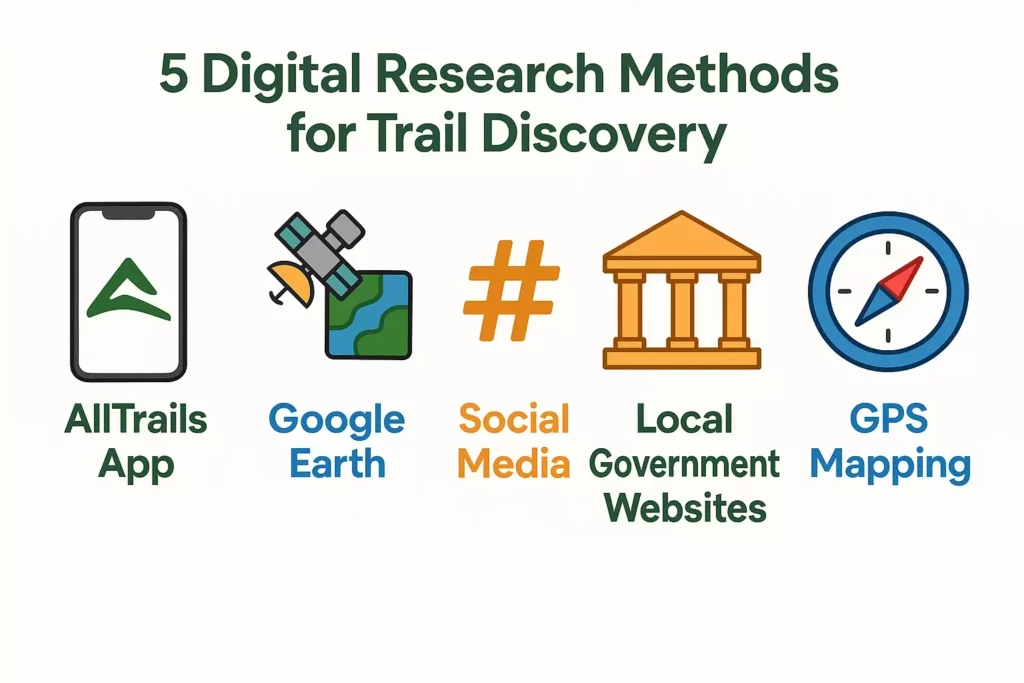
Modern technology offers powerful tools for uncovering hidden hiking opportunities. AllTrails remains one of the most comprehensive platforms, but don’t just browse the popular sections. Use filters to sort by difficulty, length, and user ratings while focusing on trails with fewer reviews. Often, the best hidden gems have only 10-50 reviews compared to hundreds for popular trails.
Google Earth provides an invaluable bird’s-eye view of your area. Look for green corridors, winding paths, and undeveloped land that might indicate trail systems. Zoom in on areas near water sources, ridge lines, and forest edges where trails commonly exist. Historical imagery can reveal old logging roads or abandoned railway corridors that may have become informal hiking paths.
Local government websites often contain treasure troves of information about lesser-known parks and preserves. Many municipalities maintain small nature preserves or conservation areas that don’t receive heavy promotion but offer excellent hiking opportunities.
Social Media and Online Communities
Facebook groups dedicated to local hiking, outdoor activities, or nature photography frequently share information about lesser-known trails. Join groups specific to your county, city, or region and actively participate in discussions. Members often share recent discoveries or ask for recommendations, providing insider knowledge you won’t find elsewhere.
Reddit communities like r/hiking or location-specific subreddits can be goldmines for trail information. Search for posts about your area and don’t hesitate to create your own post asking for hidden gem recommendations. The hiking community is generally very helpful and eager to share their favorite spots.
Instagram and photography websites can reveal trail locations through geotagged photos. Search hashtags combining your location with terms like #hiking, #trails, #nature, or #hidden. However, be respectful of photographers’ wishes if they choose not to share specific locations to protect sensitive areas.
Local Knowledge and Community Resources
Connecting with Local Experts
Local hiking clubs represent one of the most valuable resources for discovering hidden trails. These groups consist of experienced hikers who have spent years exploring every nook and cranny of your region. Attend club meetings, join group hikes, and build relationships with long-time members who often know secret spots passed down through generations of hikers.
Outdoor gear stores serve as informal information hubs where staff and customers share trail knowledge. Strike up conversations with employees who are often avid hikers themselves. Many stores maintain bulletin boards with local hiking information, group announcements, and hand-drawn trail maps from customers.
Park rangers and naturalists possess extensive knowledge about both official and unofficial trails in their areas. Visit local nature centers, state parks, and wildlife refuges to speak with staff. They can provide insights about seasonal trail conditions, wildlife activity, and lesser-known access points to popular areas.
Community Resources and Local Connections
Libraries often house historical maps, local hiking guides, and regional publications that mention trails not found online. Librarians can help you locate topographical maps, old survey documents, and local history books that might reference historic paths or abandoned roadways suitable for hiking.
Local photographers and birders frequently know the best spots for wildlife viewing and scenic photography, which often coincide with excellent hiking opportunities. Connect with these communities through camera clubs, Audubon societies, or nature photography workshops.
Longtime residents possess invaluable institutional knowledge about area trails. Strike up conversations with neighbors, local business owners, or community members who have lived in your area for decades. They often remember old paths, swimming holes, and scenic spots from before development changed the landscape.
Physical Exploration Techniques
Reading the Landscape
Learning to read natural indicators can help you identify potential trail opportunities during your explorations. Wildlife paths often follow the most efficient routes through terrain and can lead to interesting destinations like water sources or scenic overlooks. Look for worn paths through grass, compressed vegetation, or subtle depressions in the ground.
Topographical features provide clues about where trails might exist. Ridge lines often have paths following their crests for scenic views. Creek beds and river corridors frequently have parallel trails for fishing access or wildlife viewing. Saddles between hills and natural passes through rocky areas are logical locations for trail development.
Historical land use patterns can reveal hiking opportunities. Old logging roads, railroad grades, and farm paths often become informal hiking trails over time. Look for unusually straight clearings through forests, raised embankments, or wide paths that seem too substantial for current foot traffic.
Systematic Area Exploration
Develop a methodical approach to exploring your region by dividing it into sections and systematically investigating each area. Start with a 5-mile radius from your home and gradually expand outward. Focus on one section at a time, spending several weekends thoroughly exploring each area before moving on.
Drive or bike along back roads, rural routes, and dead-end streets to look for trailheads, parking areas, or informal access points. Many hidden trails begin at unmarked pullouts along lesser-traveled roads. Keep an eye out for worn paths leading into wooded areas, small parking areas without obvious purposes, or gaps in fence lines that might indicate trail access.
Follow water sources as they often lead to scenic areas and connect multiple trail systems. Creek beds, streams, and rivers create natural corridors through developed areas and frequently have parallel paths for fishing, wildlife viewing, or maintenance access.
Safety Considerations for Hidden Trails
Essential Preparation and Planning
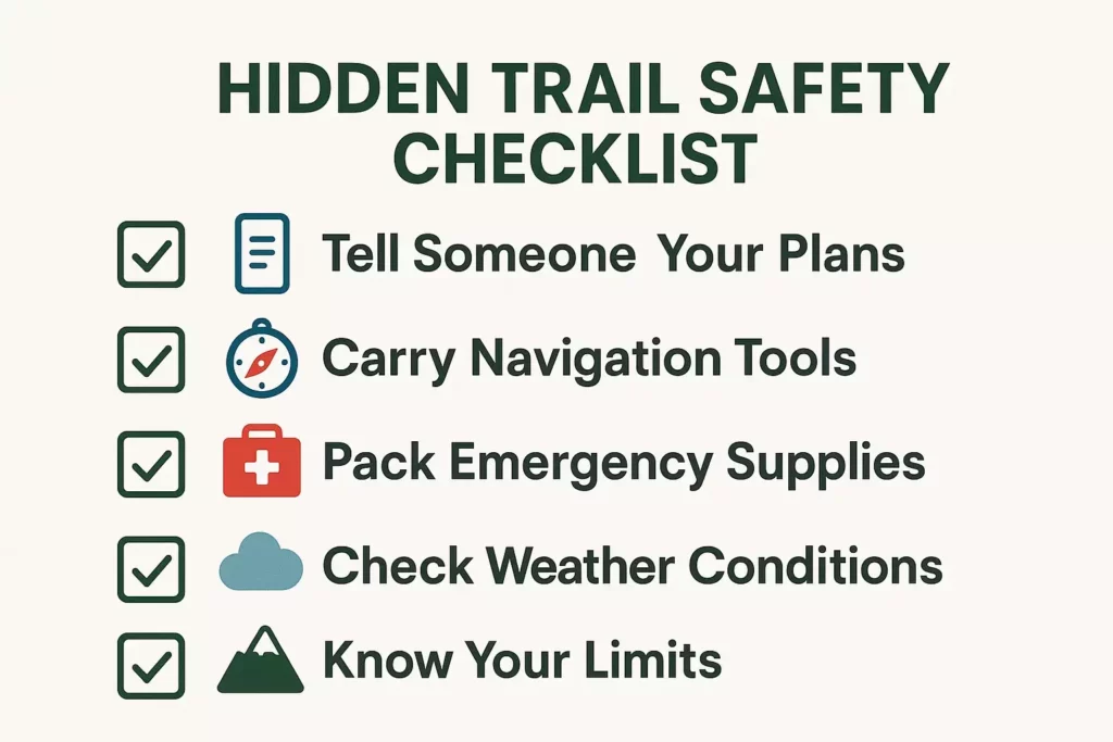
Hidden trails require extra safety precautions since they may lack proper signage, emergency services access, and cell phone coverage. Always inform someone of your hiking plans, including your intended route, expected return time, and backup plans. Create a detailed itinerary and stick to it, especially when exploring unfamiliar areas.
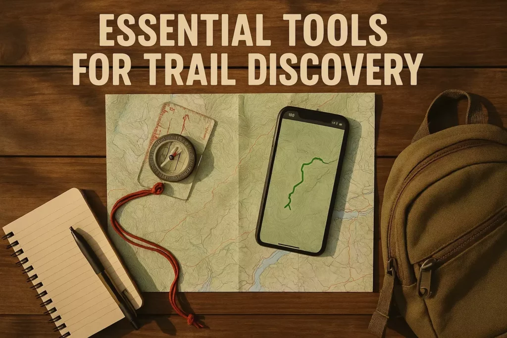
Navigation skills become crucial when hiking lesser-known trails. Carry a compass and topographical map of your area, and know how to use them without relying on GPS technology. Download offline maps to your smartphone as a backup, but don’t depend solely on electronic devices that can fail or lose battery power.
Building a comprehensive first aid kit is essential for hidden trail exploration, as emergency services may be difficult to reach. Include items for treating cuts, sprains, allergic reactions, and other common hiking injuries. Consider taking a wilderness first aid course to improve your emergency response skills.
Risk Assessment and Emergency Planning
Research potential hazards specific to your area before exploring hidden trails. These might include wildlife encounters, unstable terrain, flash flood risks, or hunting seasons that could make certain areas dangerous. Contact local wildlife agencies or park services for current information about animal activity and seasonal risks.
Weather awareness becomes more critical on hidden trails where shelter options may be limited. Check detailed forecasts and be prepared to turn back if conditions deteriorate. Carry appropriate gear for sudden weather changes, including extra layers, rain protection, and emergency shelter materials.
Develop emergency communication plans for areas with poor cell coverage. Consider carrying a personal locator beacon or satellite communicator for serious backcountry exploration. Establish check-in times with family or friends, and have clear protocols for what they should do if you don’t return as scheduled.
Responsible Trail Use and Conservation
Leave No Trace Principles
Hidden gem trails require extra care to preserve their pristine character and prevent them from becoming overcrowded or damaged. Follow Leave No Trace principles religiously, as these areas often lack the maintenance and management resources of popular trails.
Pack out all trash, including organic waste like fruit peels and nut shells that can attract wildlife and disrupt natural ecosystems. Stay on established paths when they exist, and avoid creating new trails or shortcuts that can lead to erosion and habitat damage.
Respect wildlife by observing from a distance and never feeding animals. Hidden trails often provide better wildlife viewing opportunities precisely because animals feel safer in these less-disturbed areas. Maintain this advantage by minimizing your impact and avoiding behaviors that might make wildlife wary of human presence.
Protecting Hidden Gems for the Future
Practice discretion when sharing information about your hidden gem discoveries. While it’s natural to want to share amazing finds, consider the potential impact of increased visitation on fragile ecosystems and local communities. Share responsibly by providing general area information rather than specific GPS coordinates or detailed directions.
Support conservation efforts in your area by volunteering with local trail maintenance groups, contributing to land preservation organizations, or participating in cleanup events. Many hidden gems exist on private land with public access agreements that depend on respectful use by hikers.
Engage with land managers and local officials to advocate for proper trail maintenance and protection of important natural areas. Attend town meetings, join conservation committees, or support political candidates who prioritize environmental protection and outdoor recreation access.
Building Your Local Trail Network
Connecting Discoveries
As you discover hidden trails in your area, work to connect them into longer routes that provide more substantial hiking experiences. Look for ways to link different trail systems using quiet roads, utility corridors, or greenway connections. This approach can create epic day hikes without traveling far from home.
Document your discoveries with detailed notes, photos, and GPS coordinates for future reference. Create a personal trail database that includes difficulty ratings, seasonal considerations, notable features, and access information. This documentation helps you plan future hikes and share information responsibly with other hikers.
Seasonal exploration reveals different aspects of the same trails throughout the year. Spring wildflowers, summer swimming holes, fall foliage, and winter ice formations can make familiar trails feel like completely new experiences. Plan to revisit your hidden gems during different seasons to fully appreciate their character.
Creating Your Personal Adventure Map
Develop a comprehensive understanding of your local trail network by creating detailed maps that combine multiple sources of information. Include official trails, informal paths, access points, parking areas, and notable features like waterfalls, viewpoints, or historical sites.
Rate and categorize your discoveries based on difficulty, scenery, solitude level, and seasonal accessibility. This system helps you recommend appropriate trails to friends and family based on their interests and abilities. Consider factors like family-friendly features when evaluating trails for different user groups.
Plan progressive adventures that gradually build your skills and confidence for more challenging explorations. Start with shorter, well-documented trails before venturing into more remote areas that require advanced navigation skills and emergency preparedness.
Seasonal Strategies for Trail Discovery
Maximizing Year-Round Opportunities
Each season offers unique advantages for discovering hidden trails in your area. Winter exploration reveals trail structures normally hidden by vegetation, making it easier to spot old logging roads, abandoned railways, or informal paths. Snow cover also provides excellent tracking opportunities to follow wildlife trails that might lead to interesting destinations.
Spring reconnaissance takes advantage of leafless trees and minimal undergrowth to spot potential hiking routes. This season is ideal for aerial scouting using drones (where legal) or elevated viewpoints to identify promising areas for future exploration. Spring also brings migrating birds and wildflower blooms that can lead you to special ecological areas.
Summer and fall provide the best conditions for actually hiking newly discovered trails, with longer daylight hours and generally stable weather. Use these seasons to thoroughly explore areas you’ve identified during winter and spring scouting missions.
Weather-Dependent Opportunities
Drought conditions can reveal normally hidden features like creek crossings, old bridge foundations, or seasonal waterfalls that indicate trail locations. Low water levels also make it easier to explore streamside paths and riverside trails that might be inaccessible during high water periods.
Post-storm exploration can uncover new trail opportunities as fallen trees create natural bridges or reveal previously hidden paths. However, always prioritize safety and avoid areas with unstable trees or flood-damaged terrain until conditions stabilize.
Seasonal access changes affect many hidden trails, particularly those crossing private land or areas subject to hunting seasons. Research these patterns to maximize your exploration opportunities while respecting landowner wishes and safety considerations.
Advanced Research Techniques
Historical and Archaeological Resources
Historical maps provide fascinating insights into trail systems that predate modern development. Visit local historical societies, libraries, and government offices to access old survey maps, railroad charts, and military maps that show paths no longer marked on contemporary maps. Many of these historical routes remain passable and offer unique glimpses into your area’s past.
Archaeological sites often have associated trail networks that connected settlements, water sources, and resource areas. Research Native American trails, colonial roads, and pioneer routes that may still exist as hiking paths. Contact local archaeological societies or university departments for information about documented historical trail systems.
Land use evolution reveals opportunities where former agricultural areas, industrial sites, or transportation corridors have reverted to natural conditions suitable for hiking. Old railroad grades make particularly excellent trails, as they were engineered with gentle gradients and stable surfaces that remain viable decades after abandonment.
Scientific and Environmental Resources
Watershed maps and ecological surveys can identify areas with high biodiversity or unique natural features that often have informal trail access. Contact local environmental organizations, watershed groups, or university research departments for information about study sites and monitoring locations that may have established access routes.
Wildlife corridors and migration routes frequently have parallel trails for research and observation purposes. These paths often provide excellent hiking opportunities while supporting important conservation goals. Connect with wildlife biologists, bird banding stations, or ecological research projects to learn about these specialized trail networks.
Geological features like fault lines, mineral formations, or unique rock outcroppings often have informal trails created by geologists, rockhounds, or nature enthusiasts. Contact local geology clubs, mineral societies, or university geology departments for information about field study locations and access routes.
Technology Integration and Modern Tools
GPS and Mapping Applications
Offline mapping capabilities become essential when exploring hidden trails in areas with poor cell coverage. Download detailed topographical maps to your smartphone using apps like Gaia GPS, AllTrails Pro, or Avenza Maps. These tools allow you to navigate confidently even without internet connectivity and help you mark waypoints for future reference.
Track recording helps you document new discoveries and share them responsibly with other hikers. Record your routes using GPS devices or smartphone apps, noting important features like water sources, viewpoints, difficult sections, or seasonal obstacles. This documentation proves invaluable for planning return visits and helping others enjoy your discoveries safely.
Satellite imagery analysis using tools like Google Earth Pro or ArcGIS Online can reveal trail patterns invisible from ground level. Look for consistent clearings, switchback patterns, or bridge crossings that indicate established trail systems. Historical imagery comparison can show how trails have evolved over time and identify abandoned routes worth investigating.
Social Media and Digital Communities
Geotagged photography on platforms like Instagram, Flickr, or 500px can reveal hidden locations through careful analysis of image metadata and background features. However, respect photographers’ privacy and conservation concerns by not pressuring them to reveal specific locations for sensitive areas.
Crowdsourced mapping projects like OpenStreetMap often contain trail information contributed by local hikers and outdoor enthusiasts. These collaborative platforms may include informal trails, seasonal routes, and local knowledge not found in commercial mapping products.
Digital trail journals and hiking blogs provide detailed firsthand accounts of trail conditions, access information, and seasonal considerations. Search for blogs specific to your region and reach out to authors who often welcome questions from fellow hikers and may share additional unpublished information about their favorite spots.
Building Long-Term Exploration Skills
Developing Outdoor Expertise
Navigation proficiency forms the foundation of successful hidden trail exploration. Practice using compass and map navigation in familiar areas before venturing into unknown terrain. Learn to identify terrain features, bearing calculations, and triangulation techniques that help you navigate confidently without GPS dependency.
Weather interpretation skills help you make safe decisions about when and where to explore. Study local weather patterns, seasonal variations, and microclimate effects that influence trail conditions in your area. Understanding these patterns helps you time your explorations for optimal safety and success.
Natural history knowledge enhances your ability to read the landscape and identify promising areas for exploration. Study local ecology, geological formations, and wildlife behavior to better understand how natural systems create the features that make hiking areas special.
Physical and Mental Preparation
Fitness progression enables you to tackle more challenging hidden trails as your skills develop. Start with shorter, easier routes and gradually build endurance, strength, and technical skills needed for more demanding explorations. Consider the proper gear selection and packing strategies that support longer adventures.
Risk assessment abilities help you make sound decisions about which trails to attempt and when to turn back. Develop situational awareness, emergency planning skills, and decision-making frameworks that prioritize safety while still allowing for adventurous exploration.
Documentation habits ensure you can share your discoveries responsibly and return to favorite spots easily. Develop systems for recording trail information, photographing key features, and maintaining exploration logs that support both personal enjoyment and community benefit.
When planning family adventures, consider activities that engage children and ensure everyone has appropriate gear for various weather conditions. Remember that hidden trail exploration can be adapted for different skill levels and group compositions.
Conclusion
Discovering hidden gem hiking trails in your backyard transforms ordinary weekends into extraordinary adventures while building deep connections with your local landscape. The strategies outlined in this guide—from digital research and community engagement to physical exploration and safety preparation—provide a comprehensive framework for uncovering the natural treasures that exist closer to home than most people realize.
Start your journey today by choosing one research method from this guide and dedicating just one hour to exploring trail possibilities in your area. Whether you begin by joining a local hiking group, studying historical maps at your library, or simply driving down unfamiliar back roads with your eyes open for trailheads, that first step will launch you into a rewarding hobby that provides years of local adventure.
Remember that every expert trail finder started as a beginner, and the most spectacular hidden gems are often discovered by persistent explorers who combine multiple research approaches with respectful, safety-conscious exploration practices. Your backyard contains hiking treasures waiting to be discovered—the only question is which amazing trail you’ll find first.
Take action this weekend by implementing at least two strategies from this guide, and begin building your personal map of local hiking gems that will provide a lifetime of outdoor enjoyment just minutes from your front door.